
When it comes to discussions of climate change, much of the debate is focused on that small part of the globe that is – for now, at least – dry land: the impact on cities on or near coastlines; dealing with droughts associated with altered weather patterns; reduced habitat for wild plants and animals; and shifting climate zones for food crops.
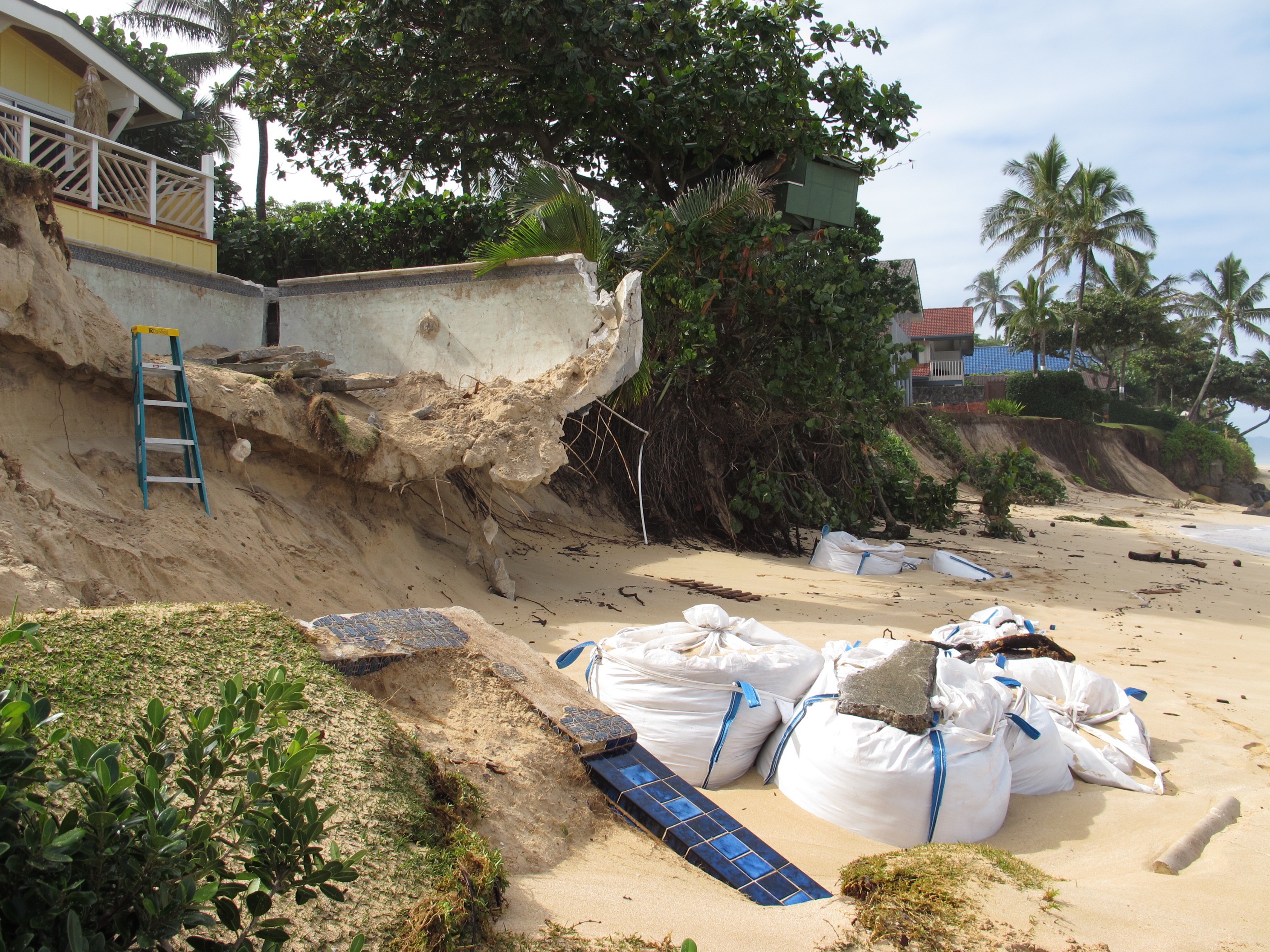
For the most part, the ocean gets the attention that is its due only at times when it comes crashing, uninvited, onto coasts, where – as has recently happened in Hawai`i – it takes out roads, undermines buildings, and erodes beaches.
But at the Ocean Sciences Meeting of the American Geophysical Union, held in New Orleans earlier this year, the marine environment and the vitally important role it plays in the dynamics of climate change were front and center.
* * *
Bye Bye Big Fish
While changes in the ocean may be most visible near or in the shallows – coral bleaching, for example, or coastal erosion – deep-water habitat for fish is being altered as well.
Phoebe Woodworth-Jefcoats, a researcher with the National Oceanic and Atmospheric Administration’s Pacific Islands Fisheries Science Center (PIFSC), outlined disruptions to the ocean that are certain to affect populations of fish that are the bread-and-butter of the Hawai`i longline fleet: the top ocean predators including bigeye tuna and billfish.
Woodworth, along with Jeff Polovina, also with the PIFSC, and Jeff Drazen, with the University of Hawai`i at Manoa School of Ocean and Earth Science and Technology, looked at 11 different climate models. All were in strong agreement that in coming decades, ocean temperature would rise, zooplankton would decline, and that, by the end of this century, the carrying capacity for large fish in the North Pacific ecosystem would suffer a reduction of between 20 percent and 50 percent.
“As the ocean gets warmer, fish need to eat more,” Woodworth-Jefcoats said at an AGU news briefing. “But at the same time, zooplankton densities are lower. These are the foundation of the food web. So even as the fish need more food, there is less available for them to eat.”
That, she continued, means that “fish won’t be able to grow as big, there will be fewer fish, or, most likely, some combination of these two impacts.
In addition to species declines, some species may not survive at all. Woodworth-Jefcoats and her colleagues determined that in parts of the subtropical North Pacific, the ocean temperature may rise to levels higher than what some fish are able to tolerate. “These waters may see a loss of up to three or four tuna and billfish species, out of a total of roughly 20 species.”
The spatial distribution of tunas and billfish is likely to change as well, moving northward.
“Species prefer specific temperature ranges,” she said. “When temperatures change, fish will relocate to stay within their preferred conditions. When the tropics get too warm, some species will leave these waters.”
The projected decline of between two and five percent per decade “can have a large impact on the composition and magnitude of catches,” she said. “Some fishers who used to home-port in Honolulu have already moved to San Francisco.”
The subtropics – where the Hawai`i-based fleet now spends most of its effort – will be hardest hit, Woodworth-Jefcoats added. “The area just won’t support as many commercially valuable fish.”
This study echoes some of the findings of one published by Progress in Oceanography in 2010 by several scientists, including John Sibert and John Hampton of the Western Pacific Fishery Management Council’s Scientific and Statistical Committee. That study, which modeled climate change impacts to Pacific bigeye tuna, found that habitat in the Eastern Pacific improved over the coming decades, while that in the Western Pacific, where the Hawai`i longline fleet catches most of its bigeye, “becomes too warm for bigeye tuna spawning” and “natural mortality of older stages increased due to lower habitat values (too warm surface temperatures, decreasing oxygen concentration in the sub-surface and less food). This increased mortality and the displacement of surviving fish to the eastern region led to stable then declining adult biomass at the end of the century,” an abstract for the study states.
* * *
That Sinking Feeling:
The Future of Reefs
“Now we can all have a group cry.”
Jessica Carilli, the moderator of a panel on coral reefs, made the comment only half in jest following a talk by Oberlin University professor Dennis Hubbard on the future of reefs.
Hubbard, who has studied reefs around the world for the last four decades, gave his audience of scientists concerned with reef health little hope that the subject of their life’s work would be around as living structures for much longer.
Most of Hubbard’s colleagues on a panel at the Ocean Sciences meeting that discussed coral health had focused on the ability of stony corals to thrive in acidic oceans with limited supplies of reef-building calcium.
Talk of pH levels and aragonite (calcium carbonate) saturation dominated the discussion.
Until Hubbard came along.
What he focused on was a very basic question: Will reefs and reef islands be able to keep up with sea level rise in coming years? Put another way, how fast is sea level rising, and can reefs grow fast enough to keep pace?
To answer the question, Hubbard compared reef-building rates in the early Holocene period to the rates of coral growth he has been measuring since 1979 from 64 different sites scattered around the world.
In the early Holocene, from about 12,000 years ago to 7,000 years ago, glaciers melted and sea levels rose dramatically. Rates of sea level increase span a range, depending on what period is at issue and what evidence is considered. Still, sea levels rose fast enough to drown most coral reefs. Back then, “fifty-one percent of reefs were unable to keep up with sea level rise,” Hubbard said.
Today, reefs may face a similar fate.
At Cane Bay in the Virgin Islands, for example, the rate at which the reef is growing has declined 26 percent since 1979, he said.
If that were not bad enough, he continued, the “export rate” – the rate at which reefs experience the loss of reef-building materials to bioerosion (coral-munching fish and sponges), mining, normal flushing, and hurricanes, among other things – was accelerating.
Compounding the problem for reefs is the rapidly rising sea level.
“Before we were doing anything,” he said, “the rate of reef accretion was already building slower than sea level is rising now.”
With the predicted increase in storm severity and frequency associated with climate change, reefs may not stand a chance.
Hubbard again referred back to Cane Bay, hit hard by Hurricane Hugo in 1989. The volume of sediment that was removed from the reef area and flushed to deeper water was orders of magnitude greater, in that one event, than what would be washed out in the course of a normal day. With increased storm strength and frequency predicted to occur with climate change, nearshore areas will be hit even harder.
“If you increase storm frequency by just five percent,” he said, “twenty to 70 percent of the sediment will be taken out of the reef.”
All this is bad news for the terrestrial areas that have been protected in the past from the worst of the waves. If the water over the reefs increases by just 2 centimeters, “you’ll allow 15 percent more energy to hit the coast. It’s a dramatically more unstable system,” he said.
Rising seas will eventually encroach into now-populated areas, but well before that happens, changes in the nearshore environment will have already forced people living in those areas to flee, he said.
The higher storm surges associated with lost reefs “will ruin islands’ water supplies,” he said. “Islands will be uninhabitable long before they’re under water.”
* * *
El Niño Linked
To Coastal Erosion

Predictions of an increasingly frequent, and increasingly strong, El Niño-Southern Oscillation (ENSO) aren’t all bad for Hawai`i. Conditions for the Eddie Aikau surf tournament might occur a lot more often in coming years than in the past.
But there’s a down side as well. As O`ahu’s coastal highways crumble into the sea, driving to the North Shore to view the contest will be a challenge.
Patrick Barnard of the U.S. Geological Survey in Santa Cruz, California, has been studying what happens to coasts in years with a strong El Niño, and the news is not good.
“Coastal flooding from sea-level rise alone could displace around 200 million people by 2100,” Barnard said in his talk at the Ocean Sciences meeting. But local impacts are not well understood, and impacts will vary among regions, he noted.
In an effort to better understand ways in which ocean climate variability is linked to coastal change, Barnard looked at data from 1979 to 2012 gathered from four dozen beaches around the Pacific basin as well as in its center (Hawai`i) to determine which coastal areas might be most vulnerable to erosion. He then correlated the El Niño events with eroding coastlines.
Among other things, he found that in winter months – December, January, and February – when a strong El Niño is present, shoreline erosion in Hawai`i increases 67 percent over non-ENSO years. In California, the rate is nearly double that: 129 percent.
The future is almost certain to be worse, with more frequent and extreme El Niños predicted to occur.
“If the frequency of extreme ENSO events increases,” he said, “then populated regions on opposite sides of the Pacific will be alternately exposed to extreme coastal erosion and flooding, independent of sea level rise.”
“Right now, sea-surface temperatures are at historic highs. Sea level is at historic highs, and extreme wave energy is 45 percent above normal,” he said.
* * *
Next Hurricane Season
Will Be ‘Particularly Intense’
Even in years when El Niño is absent, it still packs a punch – in the form of strong hurricanes. Julien Boucharel, formerly with the University of Hawai`i School of Ocean and Earth Science and Technology (SOEST) and now at the Climate Change Research Center in the University of New South Wales in Sydney, described his work linking hurricane activity to the El Niño cycle.
“The Eastern Pacific is the second most active region in terms of tropical cyclones,” Boucharel said, adding that the last two seasons “have been the most intense on record, especially in the vicinity of Hawai`i.” And, if his predictions are correct, hurricane activity in the region in 2016 may match or exceed last year’s.
To explain this, Boucharel and colleagues looked at the effects of El Niño not on sea surface temperature, but on the temperature of water at depths of up to 100 meters. There they found a mechanism that helps predict just how intense cyclone activity will be in the Eastern Pacific.
In El Niño years, characterized by warmer than usual temperatures, equatorial water up to 100 meters deep heats up. As these currents of warmer deep water reach the Eastern Pacific, they rise up in the water column, fueling hurricane activity.
By tracking these waves as they move from the Central Pacific to the American coasts, researchers can better forecast hurricane activity, Boucharel said.
For 2016, “we can expect a very strong season in the Eastern Pacific. The next season is going to be particularly intense,” he said, although just how intense will depend on atmospheric conditions in the next month or two. “We will wait for March to see atmospheric variability,” he added.
* * *
Hazard Mapping
For Hurricanes
Ning Li, a researcher with the UH School of Ocean and Earth Science and Technology’s Pacific Islands Ocean Observing System, described modeling that she has done to estimate just how far inland storm surges associated with hurricanes will reach by the century’s end.
By then, under what is regarded as the most likely climate-change model, the sea level will be anywhere from 0.4 meters to 0.8 meters (roughly a foot and a half to three feet) higher than it now is. In her modeling scenarios, Li used a figure of 0.6 meters, around two feet.
In the “most critical hurricane event,” Li said, a Category 5 hurricane approaches O`ahu from the south. By the time it reaches the island, she continued, it will probably have weakened to a Category 3, but at the same time, wave heights, estimated at 10 feet while the storm is at sea, will have increased as they run into the island’s steep underwater slopes. The high waves will damage buildings and roads along the coast, but the actual peak of storm surge, when storm water runs far inland, will come later, as longer-period waves reach the coast. On O`ahu’s south-facing shore, areas from Diamond Head to Kapolei are predicted to be inundated by the storm surge. Mapunapuna is completely under water and the airport is flooded, as are Kaka`ako and Waikiki.
The “second most critical hurricane event” involves a storm approaching from the southwest, with the maximum wave height and surge occurring at the same time. The effect on land is, however, much the same.
— Patricia Tummons
Volume 26, Number 10 April 2016
Leave a Reply