
It’s becoming a regular thing. A little too regular for some.
On February 27, the state Board of Land and Natural Resources faced yet another case where landowners had to pay fines and fees and obtain an after-the-fact use permit and an easement because erosion had caused their private, shoreline property to become state-owned Conservation District land.
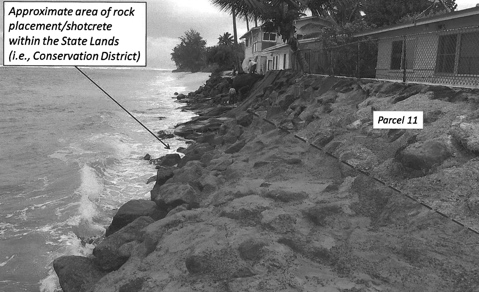
In 2002, the Department of Land and Natural Resources’Office of Conservation and Coastal Lands became aware that a small portion of an unpermitted seawall along property owned by August and Veronica Monge of Hau`ula, O`ahu lay within the Conservation District. Although it was the Monges who brought the matter to the DLNR’s attention, the Land Board fined the couple $600 for the unauthorized construction, which occurred before they bought the property in 2001, and they were required to either remove the wall or apply for an after-the-fact Conservation District Use Permit.
The couple applied for a CDUP, but by the time the matter was ready to come to the Land Board, erosion had caused nearly the entire seawall to fall within the Conservation District. Driven by Hawai`i Supreme Court decisions, the state has changed the way it now determines where the shoreline lies, and this, too, has contributed to the wall being set further inland from the coast, OCCL administrator Sam Lemmo told the Land Board.
“Now we have an after-the-fact [permit] for the whole wall, when, in 2002, it was a little bit,”he said, adding that if the Land Board were to approve the CDUP, the Monges would also need to obtain an easement for the encroachment on state land.
The board ultimately approved the permit, but not before Hawai`i island Land Board member Stanley Roehrig called on the OCCL and the state, in general, to find ways to address the effects of coastal erosion on shoreline structures in a broader way, rather than one property at a time.
“I think the state needs legislation that treats everyone identical. Because of climate change, the sea is rising. So how are we going to deal with it?”Roehrig asked.
A study by University of Hawai`i scientists published recently in the journal Natural Hazards found that based on historical erosion rates and sea level rise projections by the Intergovernmental Panel on Climate Change (IPCC), coastal erosion of Hawai`i beaches may double by mid-century, a March 23 press release states.
“When we modeled future shoreline change with the increased rates of sea level rise projected under the IPCC’s ‘business as usual’ scenario, we found that increased SLR causes an average 16 to 20 feet of additional shoreline retreat by 2050, and an average of nearly 60 feet of additional retreat by 2100,” Tiffany Anderson, lead author and post-doctoral researcher at the UH-Manoa School of Ocean and Earth Science and Technology, said in the release.
“This means that the average amount of shoreline recession roughly doubles by 2050 with increased SLR, compared to historical extrapolation alone. By 2100, it is nearly 2.5 times the historical extrapolation. Further, our results indicate that approximately 92 percent and 96 percent of the shorelines will be retreating by 2050 and 2100, respectively, except at Kailua, Oʻahu, which is projected to begin retreating by mid-century,” she said.
Because of climate change, Roehrig said at the Land Board meeting, “there’s going to come a time when every single beachfront lot is going to be in the Conservation District. He argued that the case-by-case way the DLNR deals with the resulting problems is unwieldy and noted that since he began serving on the Land Board last July, about a dozen shoreline erosion-related cases have come before it.
“I cannot imagine the amount of time it takes you to work up one of these. I read this stuff and my eyes glaze over,”he said, referring to OCCL staff.
And when heavy fines for unauthorized emergency shoreline work are involved, as has happened recently for a number of properties on O`ahu’s North Shore, contested cases often follow. Given that such cases could become more common with sea level rise, Roehrig said, “You can’t pay me to come to do the ones on the North Shore. Every single one takes an hour or two and there are thousands of lots.”
He said the Legislature needs to change the law to help streamline the process, perhaps by automatically placing properties in certain areas into the Conservation District, thereby eliminating the need for a Land Board hearing on an after-the-fact CDUP. He also suggested that landowners in critical areas could be required to obtain some kind of insurance so “everybody shares the burn.”
OCCL administrator Lemmo told Roehrig that he and his colleagues constantly think about the kinds of issues Roehrig had raised.
“You’re articulating what people are feeling. …It’s not falling on deaf ears,”Lemmo said. “It’s a troubling area in land use.”
Legislative intervention has been discussed, but for now, Lemmo said, “We’re trying to kind of muddle through it day-to-day.”
“The only light I see shining on this is the fact we are the ones doing the state’s sea level rise adaptation and vulnerability report,”he said, adding that when it is finished at the end of 2017, the report should at least provide a scientific framework to address the problem.
“We need legislation before 2017,”Roehrig replied. Depending on when solutions are implemented, he suggested that land values along the shoreline are either going to skyrocket or tumble.
With significant sea level rise decades away, Lemmo said, the state has time to address impacts, “but not a lot of time. That’s why we need the time to get it right.”
Last August, the Land Board approved a memorandum of agreement between the OCCL and the University of Hawai`i’s School of Ocean, Earth Science and Technology, chiefly to help the OCCL with its efforts to “protect and conserve beaches, dunes and coastal communities from the deleterious effects of coastal erosion and sea-level rise,”an OCCL report to the Land Board states.
The agreement was made in response to the state Legislature’s creation that year of an Interagency Climate Adaptation Committee, which has been tasked with completing a Sea Level Rise Vulnerability and Adaptation Report by December 31, 2017.
Easements
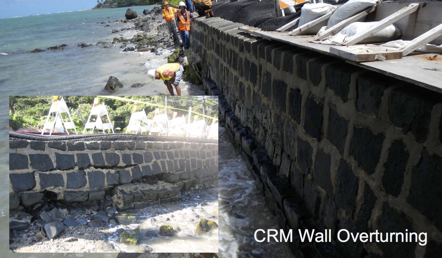
While the fines for unauthorized shoreline construction in the Conservation District can seem enormous, reaching tens of thousands of dollars in some cases, they pale when held against the potential cost of the easements that must be obtained for structures that are allowed to stay.
Because courts have determined that all land seaward of the high wash of the waves belongs to the state, for nearly every CDUP that the Land Board issues for a private seawall or shoreline structure, the DLNR’s Land Division follows up at a later meeting with a request for approval of a non-exclusive easement to cover the encroachment on state land.
At the Land Board’s March 27 meeting, Land Division administrator Russell Tsuji said his agency works closely with the OCCL on a lot of issues. Often when walls are found to be within the Conservation District, the state’s position has been that it doesn’t necessarily own the structure, even though it owns the land. Instead, the seawall is seen as an encroachment, “no different than if your neighbor built part of his wall on your land,”he told the board.
And encroachments may become more common given the way shorelines are certified now.
“The state may certify the shoreline at the face of an existing legal structure, but if the shoreline goes around and behind your wall, even if you built it legally, your wall is behind the shoreline,” Lemmo said.
It is highly likely that many thousands of beachfront landowners need an easement for their seawalls or revetments, but the Land Division does not aggressively seek them out. More often, landowners wanting to sell or renovate their property discover encroachments during the associated shoreline certification process.
Once the Land Division determines an easement is necessary, a lengthy and expensive process ensues. In its recommendation to the Land Board for approval of a non-exclusive easement, the division often includes a fine of $500 for any encroachment larger than 100 square feet, in accordance with a Land Board policy established in 2002. The easements are usually for 55 years and the landowner is required to make a one-time rental payment based on an appraisal — for which the landowner must also pay —of fair market value.
If the wall was legally built, the square-foot value of the wall would be the same as that of the submerged land upon which it sits, Tsuji told Environment Hawai`i. Generally, submerged land values are 50 percent of the abutting fast land value. Appraisals also factor in discounts based on the level of likely public use given the location and height of the structure.
In some cases, the easements have run into the hundreds of thousands of dollars. For example, a recently approved easement for a 1,400 square foot seawall fronting an apartment building on Maui cost $130,000.
“The ones for condos on Maui can be hugely expensive,”Tsuji said.
He added that some easement cases remain open long after Land Board approval because appraisals can sometimes take a year or more to complete and some landowners don’t want to pay after the appraisal comes in.
When they do pay, 20 percent of the money goes to the Office of Hawaiian Affairs, which receives rent from the use of ceded land. The rest goes to the OCCL’s beach restoration fund, Tsuji says.
Before the easements are issued, they must also receive approval from the governor and the state Legislature. In the current session, bills have been introduced to authorize a variety of shoreline easements for structures on submerged lands in Lahaina on Maui, Pulawai on Lana`i, and Waikiki, Hau`ula, Kahuku, and Kahalu`u on O`ahu.
Capping Costs
This legislative session, the DLNR has supported bills that would allow the Land Board to charge less than fair market rent for legally built shoreline structures that have, through movements of the shoreline, become encroachments.
House Bill 956 and Senate Bill 1125 would have added a new section to the state land use law for “special shoreline easements,” which could be granted for structures authorized by the government and built landward of the shoreline and within the property line at the time of construction. The Land Board would have the discretion to determine on its own the value of the special easement. Also, the easements would not have to receive final approvals from the governor and the Legislature.
In testimony submitted February 6 to the House Committee on Water and Land, DLNR interim chairperson Carty Chang pointed out that many of the structures that are now seaward of the shoreline are a liability concern for the department.
“In exchange for the granting of an easement, the Department requires insurance and indemnity protection,” Chang stated. To make it easier and more palatable for landowners to acquire easements, the DLNR wants to keep the cost down and speed up the process.
“The problem under current law is that the Board must charge fair market value as determined by an appraiser for the easement,” Chang stated. “[G]iven the volume of easements that are expected to be processed, this exemption would greatly expedite the disposition process. Allowing the easements to be granted at less than fair market value via a streamlined process would assist in encouraging compliance from littoral landowners entering into easements with the state. By resolving the liability and indemnity issues, taxpayers will have greater protection from potential legal and financial liability against the state with regard to these structures,” Chang wrote.
He added that by facilitating landowners’ compliance, the bill would reduce the burden on DLNR staff from having to pursue enforcement actions.
The Committee on Water and Land chose to defer HB 956, while SB 1125 never even got a hearing this session.
Similar bills were introduced in the 2013 Legislature. In testimony, Jesse Souki, then-director of the state Office of Planning, expressed concern at the time that accelerated sea level rise wasn’t being taken into account.
“Due to the dynamic nature of the location of the shoreline, the proposal … may promote structures within the shoreline area toward coastal hazards, including storm waves and coastal erosion. This policy could potentially increase the risk of coastal hazard threats to life and property along the shoreline,” he wrote.
Other members of the public opposed the bills outright. Neil Frazer argued that, if enacted, the bill would “effectively relieve private landowners from the burden of removing structures such as sea walls that are now in tidal waters but were built for the private benefit of those landowners.”
“That is wrong, I think,” he continued. “Landowners who build near the ocean should clearly understand that their structures will eventually fall into the ocean and require clean-up, and that they will have to pay for that clean up.”
To address the concerns raised, the 2013 House version was amended to require the Land Board to consider shoreline protection, public access, and “risks to life and property from coastal hazards” when approving easements. That requirement is also included in the bills introduced this year.
— Teresa Dawson
Leave a Reply