
Despite years-long drought conditions for much of the island of Hawaiʻi, the Hawaiʻi County Planning Department defends its use of 2007 rainfall data as the “best available data.”
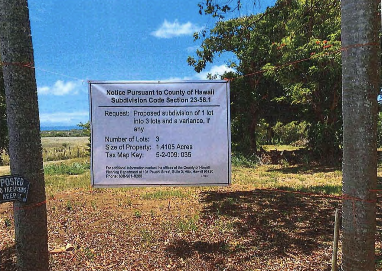
This was acknowledged by Planning Director Zendo Kern as the county Board of Appeals considered a challenge to Kern’s approval of a subdivision in North Kohala. The subdivision had been sought by the owner, Anderson Big Island Investments, LLC, of a 1.4-acre lot proposing subdividing it into three lots. The zoning, requiring minimum lot sizes of 15,000 square feet, allowed for the subdivision, but the county Department of Water Supply could not provide water to more than the one existing lot.
In such cases, the Planning Department’s rules allow for subdivisions of up to six lots to be created, so long as there is sufficient rainfall – at a minimum 60 inches a year — to support catchment systems.
In 2007, when data was compiled for the 2011 Rainfall Atlas of Hawaiʻi, the area of North Kohala where the subdivision is proposed received around 65 inches of rain a year. But a neighbor, Christine Bailey, concerned about last summer’s fires on Maui and Hawaiʻi Island, appealed Kern’s decision, noting that much more recent data from the National Weather Service did not support Kern’s agreement with the applicant that the site receives more than 60 inches of rain a year.
As Bailey’s appeal stated, “the record shown on the official [National Oceanic and Atmospheric Administration] website demonstrates that the average rainfall for the North Kohala area in question was only 46.6 inches for the period 2004 through 2022. In 2021 the rainfall was below 30 inches for the first time on record, and in 2022, the rainfall was below 29 inches. The State of Hawaiʻi Climate Change Portal notes that, ‘since 2008 overall, the islands have been particularly dry.’”
“The [county] rules are not ambiguous in requiring that lots to be served via catchment must have the minimum specified rainfall,” the appeal noted, going on to quote Rule 22-4: “all lots to be served by catchment shall have an average annual rainfall of not less than 60 inches. The annual rainfall can be proven by rainfall records at comparable rain gauges or by the USGS rainfall map.” There is just one exception, for lots that are at least 20 acres in size and at least four times the minimum lot size allowed by zoning – a condition that does not apply in this case.
Under questioning from Jean Campbell, the deputy corporation counsel representing the Planning Department, Kern defended his reliance on the 2011 Rainfall Atlas as “the standard, best available data that we use for all of our variances. We’re not subjective on which ones we pick and choose from. This is the one we use across the board. All of our variances for Rule 22 are based on that.”
Campbell asked if it would be unusual for Kern’s department to stray from that standard.
“I believe it would be not only out of the ordinary. I believe that it would be subject to an appeal and I would be sitting here feeling very differently because I was using subjective information versus the best standard available data that we have.”
Who would decide whether the standard should be updated? Campbell asked.
“That would be mine and that would take some work,” Kern replied.
Commenting on the 60-inch rainfall standard for a water variance, Kern suggested he would be inclined to relax it by lowering the threshold for a variance.
He was asked by Whitaker whether the Planning Department had considered updating its rainfall figures.
“Yeah,” Kern replied, “you know, sometimes I do contemplate that and I contemplate looking and changing the rainfall data. And my thought around it is generally to lower the rainfall [threshold] amount. There’s a big reason why. We need housing. Housing is a huge, huge issue. We have our local children being exported all the time because they can’t afford housing.
“One of the biggest impediments to housing is water. The [Department of Water Supply] does not necessarily engage in developing new systems. They work on their systems. They work on increasing some capacity, but you can talk to the director of the Water Department and they say the primary job is to maintain our systems. So in an effort to move forward from a sustainability standpoint as well as a housing standpoint, I would actually contemplate lowering that amount to allow more people to be able to live here and utilize catchment systems.”
The Board of Appeals voted unanimously to affirm Kern’s decision and deny the appeal.
Tom Giambelluca, lead author of the Rainfall Atlas, was asked whether the county’s reliance on data from that source was appropriate, given recent trends.
“The Atlas provides a 30-year mean estimate for the period ending in 2007,” he replied. “We have not put out an update for the 1978-2007 mean maps in the Atlas. However, we have developed monthly maps going back to 1920 and continuing up to the present. On our list of high priority tasks is to use the monthly maps to produce annual, ten-year, and thirty-year mean maps for the most recent periods and for other periods.
“The question of what rainfall metric is most appropriate in the planning realm is a little out of my area of expertise. But I will say that while the long-term mean is very relevant, consideration of the year-to-year variability could also be useful. Rainfall is highly variable on all time scales. Using data from only the last few years, for example, is not necessarily a better measure of what the average will be in the coming years than using the long-term mean from an earlier period.
“On the other hand, we know that climate warming is likely to affect weather patterns in the Hawaiʻi region and might already be affecting rainfall, which would argue against using an average based on data from decades ago.”
But, he continued, “I don’t fault anyone for choosing to use the Rainfall Atlas mean maps as guidance. We just haven’t yet made other relevant rainfall metrics readily available. We hope to do so in the near future.”
Jeff Darrow, deputy planning director for the county, was asked about the use of rainfall data that did not reflect current trends.
“We have been working with the state to incorporate their current rainfall data layer for our GIS,” he replied, but it has been a process to get approval. It is my understanding that we are close and once incorporated with our GIS, it will provide constant updated rainfall data.”
— Patricia Tummons
James Keim
Using accurate and updated rainfall information is important in the planning of housing that is dependent on catchment systems. Buyers of properties that lack sufficient rainfall often face significant and ever growing costs to truck water onto their property and may have no long term guaranteed source of water availability. Fire hazards also increase when the owner is unwilling or financially unable to truck in sufficient water to keep their storage tanks full.