
By Patricia Tummons
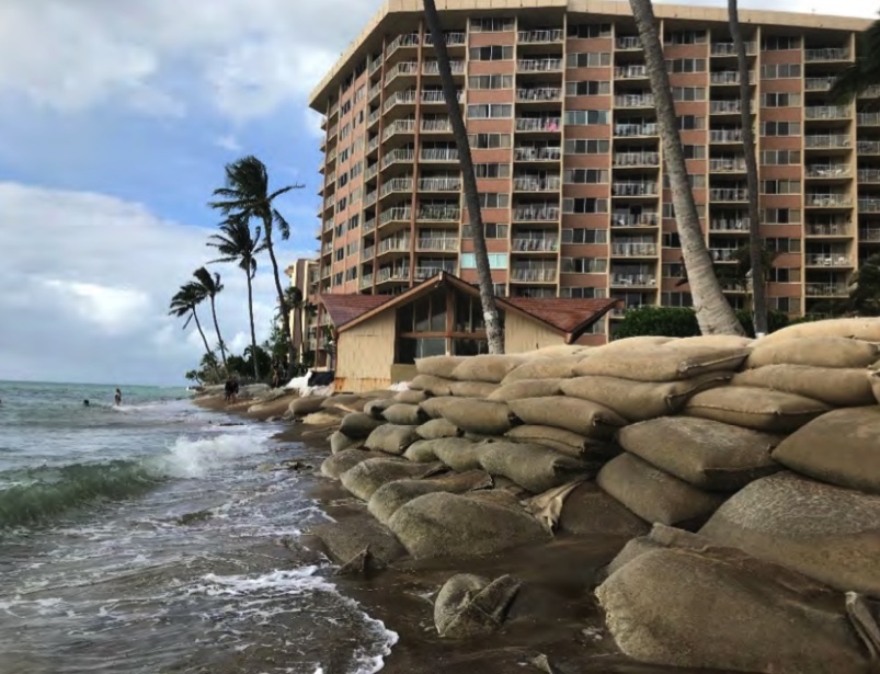
Kahana Bay, about seven miles north of Lahaina on Maui’s west side, has seen substantial erosion in recent years, exacerbated by a series of shoreline protection structures installed over the last few decades. Now, a group that represents owners of nine condominiums and one lot with a single-family house has come up with a plan to mitigate erosion and protect the existing buildings.
The plan developed by that group, the Kahana Bay Steering Committee, involves construction of seven T-groins extending 215 feet from the shore and rising about six feet above sea level, dredging of three offshore sites for sand, placement of up to 100,000 cubic yards of sand along the eroded beach so that it approximates the beach that existed in 1975, “reinforcement” of a headland at the northern end of the project area, and placement of a three-foot-high vegetated sand berm between the replenished beach and the condos for most of the 3,700 lineal feet of shoreline fronting the structures. The average beach width will be about 65 feet, with areas near the groins having beaches up to 80 feet wide.
Cost of the project, including maintenance costs over five decades, is estimated to run somewhere between $26 million and $40 million.
A draft environmental impact statement (DEIS) published last month provides details. (Last month’s DEIS is actually the second one; the first, released last April, did not include agency consultation comments and responses in a separate section.)
The DEIS, which runs to more than 1,000 pages, states that the action is needed if the area is to exist at all under projected sea-level (SLR) rise scenarios. “According to the state of Hawaiʻi SLR Report …, the Kahana Bay area is projected to be permanently lost if no intervention is taken,” the document states. Sea-level rise exposure areas under four different scenarios show that even a half-foot rise would leave the ocean lapping at the foundations of almost every building in the project area. A rise of 3.2 feet, which could occur as early as 2060, would put the lower levels of the buildings under water, with the ocean extending inland as far as Lower Honoapiʻilani Road.
Shoreline erosion rates for the area range from half a foot per year to almost two feet per year, with an average of about a foot annually. This, the DEIS states, “is caused by a multitude of factors, including tropical storm and hurricane events, land subsidence, changes in sediment supply, prevalent wind and wave patterns, runoff drainage in the area, and rising sea levels. Episodes of rapid erosion caused by severe wave and current conditions have led to the use of a variety of coastal protective structures, including sandbag revetments, seawalls, sand dune restoration, and sheet-pile structures along the entirety of the shoreline.” Only about a third of those defenses fronting 1,200 feet of the 3,700-foot-long project area were installed with permits for what the DEIS describes as “temporary erosion control.”
The built-up beach — rising to an elevation of around 8 feet above sea level — and the additional three-foot-high sand berm are expected to provide a total of 11 vertical feet of protection to the Kahana Bay properties. Still, the DEIS states, the groins and other measures proposed have been designed “taking into account approximately one foot of SLR.”
If the project is to move forward, many issues remain to be addressed. The Board of Land and Natural Resources must first approve the final EIS and grant a Conservation District Use Permit for work to occur on submerged land and will also require easements from the DLNR to occupy state submerged land. Additional permits will be needed from the Army Corps of Engineers, the state Department of Health, and Maui County.
Rejected Alternatives
If nothing is done, then “current forms of shoreline protection will be allowed to continue,” the DEIS says. All 10 properties in the project area have some form of armoring — vegetated sand berm, rock revetment and rock, rock and concrete, sandbag revetments (including one with a seawall backstop), and three seawalls.
Under the “no action” alternative, those “temporary” barriers would remain. But, the DEIS says, so would “threats to public safety and habitable structures,” “continued coastal hazards,” “water quality concern from shoreline erosion,” and “little to no sandy beach habitat.”
Another rejected alternative is described in the DEIS as “accommodation.” That would involve essentially making adjustments to rising sea level by, among other things, vacating parts of buildings that may be inundated or otherwise threatened by encroaching water and relocating utilities and other supporting services. Downsides of this approach include “continued coastal hazards,” “possible compromise of foundations,” water-quality concerns, and no protection of the beach.
Managed retreat — a much-touted but still inchoate approach — was discussed as a possible alternative. “Managed retreat,” the DEIS states, “is essentially shifting development inland from the coast either by the physical movement of structures or changing the restrictions and management of Hawaiʻi’s coastal areas. … A variety of managed retreat approaches may be used. The planned obsolescence approach, for example, requires the incremental removal of structures as they reach the end of their useful lifespan. Other approaches include eminent domain, voluntary buyouts and relocation, and transfer of development rights.”
The DEIS notes that there are no “formal managed retreat master plans … or standardized strategies for conducting managed retreat.” However, the DEIS analyzes this option by assuming the managed retreat strategy would entail “voluntary fair market value buyouts of all private property” that is likely to flood and preventing new construction in this area.
Of the 961 condominium units in the area to be protected, 811, or 84 percent, are described as being threatened by flooding, erosion, and related damages. A table listed the fair-market values of these properties as $605 million. Nearly all could be subject to a reduction of value, in whole or part, by rising seas, per the DEIS.
A “secondary alternative” is described, should the full groin project be rejected or infeasible. That consists of replenishing the beach with sand dredged from three offshore sites, as in the preferred alternative. In this case, however, there would be no groins but rather a buried toe. This, the DEIS states, “would provide backshore protection should the erosion of the nourished beach continue towards the properties… The toe protection may be a short sloping rubblemound structure installed below the beach elevation.” The toe could rise four feet above the beach, the DEIS says, and extend “several feet below water level.”
The DEIS lists the drawbacks to this approach: “Without offshore beach stabilizing structures, the nourished beach would continue to erode at the current erosion rates and return to a depleted condition of no maintenance and continued nourishments are done. Further, the identified offshore sand sources may not contain sufficient sand volume to replenish the beach again. The secondary alternative would require nourishment events approximately every nine years, which would result in more frequent environmental disturbance. The reduced efficacy of this alternative compared to the longevity of the beach with structures rendered this alternative secondary to the proposed action.”
Also, it is projected to be more costly. Initial construction costs would be less, running from between $12 million and $19 million (compared to the construction costs for the groin system, estimated to run between $19 million and $30 million), but long-term maintenance costs would be considerably higher. For the groin system, maintenance over 50 years is estimated to cost between $7 million and $10 million, while the beach-nourishment alone approach would have maintenance costs of between $18 million and $26 million.
Financing Options
Given the substantial cost of either the preferred or the secondary alternative, the DEIS describes several approaches to financing.
Perhaps the most promising is the establishment of a Community Facilities District (CFD) by the county. Under this option, the County Council would establish a special taxing district and float a bond to cover the costs of the improvements. Repayment of the bond and debt service would be managed by the county and spread out among the owners of the condo units and the single-family home over the life of the bond.
“Although no CFD has yet been formed for Kahana,” the DEIS says, “it could potentially serve as a financing mechanism at some future juncture… However, CFD funds cannot be used for project maintenance.” Also, CFD projects must be public improvements or government-owned, the DEIS says. One option would be to “establish public improvement status of this project and facilitate the use of CFD. Maui County could take over project management, planning and construction.” A second approach would see the Kahana Bay Steering Committee “plan, obtain permits, manage, and implement the project through construction. If the county deems that the completed project meets requirements, and if the county desires to own the project, KBSC can deed improvements to the county. At that point, the county would reimburse KBSC using CFD funds.”
The County Council’s Water Infrastructure Transportation Committee discussed the project last year, but deferred action. “At the time of writing this DEIS, the use of CFD funds for the proposed action remains unresolved,” the DEIS states.
One potential hiccup in the CFD process would be a decision by some of the owners of units in the project area to oppose the CFD tax. “If there is not a consensus of the CFD between the owners within the proposed CFD, opposed owners would have the right to protest the tax,” according to the DEIS.
Yet another possible hurdle to approval of a CFD might be raised by parties who oppose shoreline protection in general. Lance Collins, an attorney who has represented several individuals and environmental groups on Maui and elsewhere, told Environment Hawai’i that some community groups in West Maui “have been suggesting creation of improvement districts to finance managed retreat.” So if the Kahana Bay residents “go in the direction of using an improvement district for beach nourishment, they will likely get a large vocal group advocating for it to be used for building retreat.”
Another option for financing outlined in the DEIS would be to apply for financing through the Federal Emergency Management Agency’s Building Resilient Infrastructure and Communities (BRIC) program. This new program is intended to help states, communities, tribes, and territories reduce the risks from disasters and natural hazards. KBSC applied for funds for scoping activities, and the Hawaiʻi Emergency Management Agency included an application for the Kahana Bay erosion control program in its own package of projects.
Yet a third financing option would be for the owners of the units that benefit from the project to raise the funds on their own. In this case, “KBSC would need to develop a cost sharing agreement. … [F]uture maintenance and public safety liability issues would be the responsibility of KBSC.”
Land Board Issues
In July, the Board of Land and Natural Resources considered a proposal by its Office of Conservation and Coastal Lands (OCCL) to streamline the permitting of smaller-scale beach restoration programs, involving the placement of up to 25,000 cubic yards of sand.
That, of course, is far less than the volume of sand involved in the Kahana Bay project.
Still, the matter of the severe problems at Kahana cropped up in the Land Board’s discussion. OCCL administrator Sam Lemmo, who for years has dealt with the problems and frustrations of both the public and landowners trying to address coastal erosion, defended the idea of beach restoration in general.
As Teresa Dawson reported in her write-up of the Land Board’s discussion (August 2021), Lemmo told the board that, “Simply playing hardball with people is not going to give us what we want. It’s going to backfire on us, in fact. We need to find a way forward that is manageable and economical and socially reasonable….”
Lemmo then cited as an example of the critical issues involved the case of the Kahana Sunset. “What the hell’s the county going to do at Kahana Sunset?” he asked rhetorically. “The building’s cracked. You know, are they going to condemn the building? Well, guess what, they gotta pay them $30 million now? Or is everybody going to step aside and say, let nature take its course, and then we have a big mess?”
Lemmo later backed off his suggestion that taxpayers would be condemning threatened buildings, and Suzanne Case, chair of the BLNR, made it even clearer: “Just for the record, I’m not sure the government would have to condemn [parcels] at full market value for something that’s seriously compromised, but it is a very thorny situation and lots to work through there.”
Sadang Family Keeps Tradition Alive in Kahana
By Patricia Tummons

Just one property along the Kahana Bay beach is occupied by a single-family home. Far from that being a luxury residence, as the context of surrounding properties might suggest, it is a small (680 square feet) dwelling, built in 1949, and valued by the county at $55,600. Other buildings on the .6-acre parcel are a carport and two sheds.
Cultural Surveys Hawaiʻi, which prepared the Cultural Impact Statement appended to the draft EIS, interviewed Felimon Sadang as part of the process of taking statements from key informants.
“Upon reaching Mr. Sadang’s family property,” CSH writes, “it became evident that they are truly a family of fishermen. Nets are hung neatly and large fish coolers are scattered about the property.”
On one side of the property is a condominium, which, the report states, built a rock wall to mitigate erosion. “Mr. Sadang pointed out that before the stone wall was built, the beach was as wide as 200 feet.”
The family tradition of fishing continues. On the day of the CSH interview with Sadang, several of his family members were out on the water. “Mr. Sadang spoke proudly of his great-granddaughter that she learned how to clean fish and right now his daughter and grandson are slowly taking over the reins to continue to perpetuate this way of life for the family,” CSH reports. “Mr. Sadang mentioned that tako (octopus) was and still is prominent in the area, same with the nehu (Hawaiian anchovy) and ogo (a type of seaweed).”
During the interview, the fishers returned. “A boat slowed to the front of the property with eight or so people on board. … [A]s the boat came closer to shore a number of people jumped out to start helping with bringing the boat out of the water. Getting the boat out of the water involved two trucks. One truck stayed on higher ground near the house and was used to pull the second truck and attached trailer up from the sand. It was an amazing thing to see.”
“The overall message I received from Mr. Sadang was that man does not come before nature. Effort may be put forth and millions of dollars used to build seawalls but the sea level is continuously rising and as humans, all we can do is adapt to the changing tides. … One of Mr. Sadang’s biggest concerns regarding this project is changing the natural flow of the environment. He is worried that moving sand from outer regions to replenish the shoreline will be destructive to the in-shore species and may have rippling effects along the coast.”
After CSH wrote up the interview, it was sent to Sadang to review. During that time, the CSH report states, “there was even more coastal erosion at his property.” The cultural impact statement includes before-and-after photos of the coast fronting the Sadang property.
“In recent conversations with Mr. Sadang, he believes that retreating from the shore and working to provide some kind of beach nourishment is necessary at this point.”
Volume 32, Number 6 December 2021
For Further Reading
The issue of Kahana Bay erosion has been addressed several times in Environment Hawaiʻi:
“‘Unprecedented’ Permit Extension Is Granted for Rock Revetment Fronting Maui Condos,” June 2020;
“Hololani Lawsuit,” New & Noteworthy, August 2018;
“Shoreline Hardening Policies,” Board Talk, September 2017.
P. Denise La Costa
When will the parties involved install T-GROINS to disapate the wave action and prevent erosion? I have suggested this to the county for 20 years.