
On December 23, the Honolulu Climate Change Commission approved guidance on how the Department of Planning and Permitting (DPP) should update the city’s shoreline setback ordinance, which has not been significantly amended in a decade.
The ordinance — which Matt Gonser of the Honolulu Office of Climate Change, Sustainability and Resiliency calls a “blunt tool” — currently requires setbacks of 40 feet. For shallow lots, setbacks can be as narrow as 20 feet.
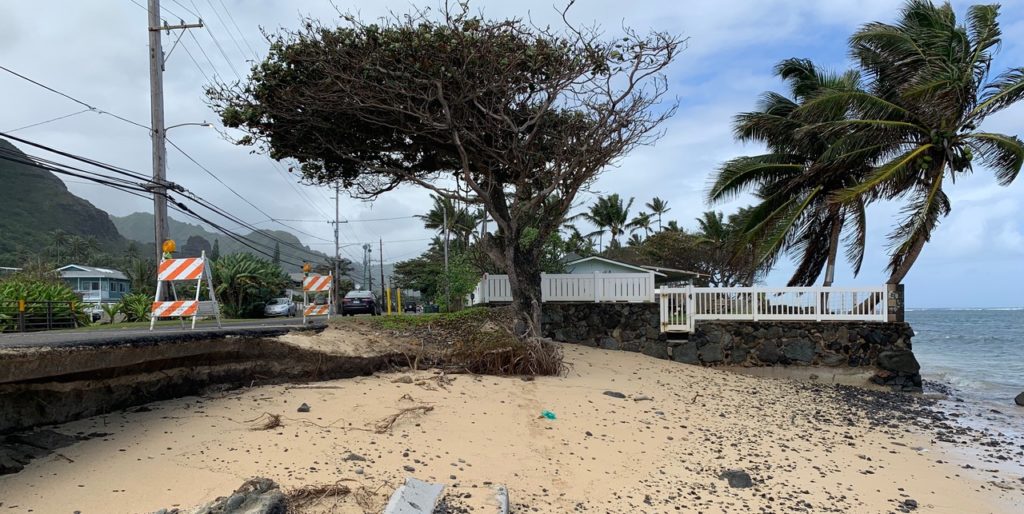
Unlike the ordinances for Kaua‘i and Maui counties, Honolulu’s does not take into account erosion rates or, in any way, recognize that shorelines are dynamic. None of the counties’ setback ordinances acknowledge the potential effects of climate change, although that may soon change.
The DPP was already in the process of amending the setback ordinance, but Mayor Kirk Caldwell last year asked the commission to provide some guidance. Over the course of meetings in November and December, the commission concluded that the ordinance should, at the very least, include a background section on climate change and sea level rise.
Because of the near-constant stream of new information regarding sea level rise, climate change, and the like, the commission also recommended that the DPP be required to revisit and amend the ordinance every five years and be provided the resources to do it.
Maui County is also in the midst of updating its shoreline setback ordinance and has proposed adding a provision to allow setbacks to be based on erosion hazard line maps developed as part of an online supplement to the state’s December 2017 Sea Level Rise Vulnerability and Adaptation Report. The maps, available on the PacIOOS viewer and hosted by the University of Hawai‘i, allow users to see the extent of various types of flooding under different sea level rise scenarios. The red erosion hazard line on the maps, which is what Maui County proposes to use, indicates where erosion-related flooding will reach under a 3.2-foot rise in sea level.
The Honolulu Climate Change Commission has proposed that the city also consider the red erosion hazard line as one of multiple criteria for determining setbacks on O‘ahu. Historical erosion rates, lot depth, and regional physical and ecological characteristics should also be considered, the commissioners found.
The commission also recommended that the city revise how it grants setback variances, since they have allowed for shoreline hardening that has shrunk beaches across the state. Commissioner Chip Fletcher had originally recommended that “nowhere in [the ordinance] or its rules should there be an allowance for shoreline hardening,” except for places such as airports and harbors where, presumably, hardening either won’t further degrade the shoreline or is necessary to protect critical infrastructure.
“We are addicted to seawalls. If you allow the addict any sort of latitude, they will go back to the drug,” Fletcher said in defense of his recommendation.
Commissioner Rosie Alegado, however, felt the language was too prescriptive and suggested softer language that merely suggests that allowances for shoreline hardening be limited to coastal segments with certain physical or ecological characteristics. The commission ultimately supported the softer language.
But before doing so, Fletcher expressed his concern that anything in the guidance document that has a loophole will be exploited by people opposed to changing the setback.
Alegado and commission chair Makena Coffman pointed out that DPP will be writing the ordinance amendments, not the commission. “We’re just guiding the ones making the amendment,” Alegado said.
Fletcher, who has tried to assist Maui County in addressing the pushback it’s received on its setback proposals, replied, “You don’t know what happens when you change a setback. They will find any little loophole and they will exploit it. It’s what lawyers are paid to do.”
Takings
If Maui County succeeds in adding to its ordinance the red erosion hazard line as a basis for shoreline setbacks, some setbacks will be much larger in many areas, and some will be smaller, according to a county report.
In those areas where setbacks would increase, some have argued that would be an unconstitutional taking of private property.
The county Planning Department has countered that current rules include provisions that ensure lots will maintain a minimum buildable depth and also provide an opportunity for landowners to request an amendment to the erosion hazard line. “These will remain. Corporation counsel determined in 2003 that these types of provisions would NOT lead to any takings, and none have been asserted in court,” a department web page on the proposed ordinance changes states.
To those who still complain that the reduction in buildable area as a result of increased setbacks would constitute a taking, the county has this to say: “Planners understand that courts interpreting the relevant law look for a very dramatic to severe, if not full, decrease in property value before determining there has been a regulatory taking.” The ordinance will still allow a landowner to build a single family residence, “even if maybe smaller and more mauka than what might have been previously allowed. Such lots retain significant residential use and monetary worth given highly valued proximity to shoreline,” the webpage states.
A Blind Spot?
Around the state, countless structures, or portions thereof, that were legally built on private properties are encroaching onto the public beach as a result of coastal erosion and/or sea level rise. But rather than use its limited staff to hunt those encroachments down and to get their owners to either remove them or pay the state fair market value for a non-exclusive easement, the Department of Land and Natural Resources’ Land Division generally pursues only those cases that come to its attention via the shoreline certification process.
Counties currently require a state certified shoreline to determine how far inland a property owner can erect a structure. Both methods for determining shoreline setbacks on Maui — using the annual erosion hazard rate or average lot depth — require a certified shoreline, which is set at the highest wash of the waves.
That may no longer be the case if proposed amendments to the county’s shoreline setback ordinance are approved.
To account for the likely effects of sea level rise, the county administration has proposed adopting a method that uses an erosion hazard line adopted by the state Climate Change Commission to establish setbacks.
Certified shorelines would only be required for owners using lot depth to establish their setbacks.
Should the county council include the red erosion hazard line as a method for determining setbacks, the DLNR’s Land Division says, that would likely inhibit the department’s ability to track encroachments on state lands, “as most of the shoreline encroachments are identified through the shoreline certification process.”
The division did not say whether or not it was concerned about the rule change creating a blind spot on Maui with regard to encroachments.
— Teresa Dawson
Leave a Reply