The forecast for Moloka‘i was grim in late August of 2018. Hurricane Lane, a category 5 hurricane, was on a track that put the Friendly Isle in its cross hairs.
Charles “Chucky” Miguel Sr. was taking no chances. The lot on which his house sits does not directly abut Waialua Stream, but it is close enough – about 200 feet from the western bank of this perennial stream on Moloka‘i’s southeastern coast – that high water generated by heavy rains or ocean swells rushing inland could flood his carefully tended gardens and lawn.
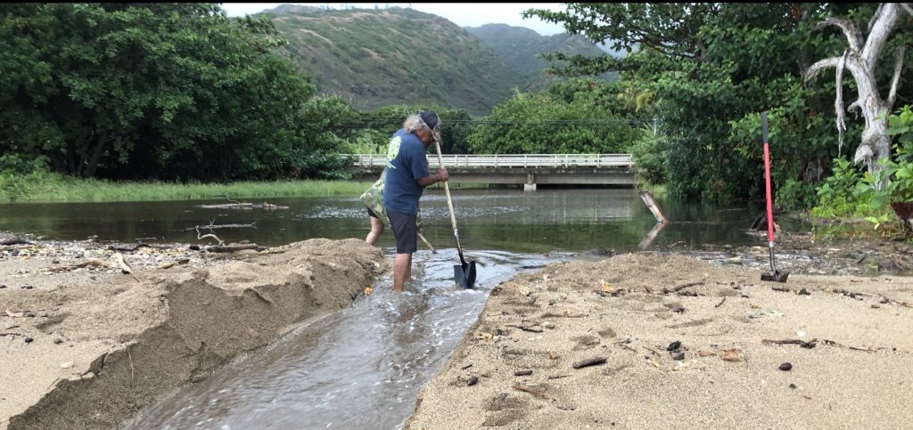
On Wednesday, August 22, ahead of Lane’s anticipated arrival on Friday, Miguel and a few of his neighbors grabbed their shovels and dug a channel through the sand bar that regularly forms at the mouth of the stream, blocking its flow and causing it to flood its banks upstream.
In addition, Miguel cleared downed trees from the stream.
Moloka‘i avoided a direct hit from Lane, although power outages occurred throughout Maui County.
But with another two months in Hawai‘i’s hurricane season, Miguel continued to be worried about potential flooding.
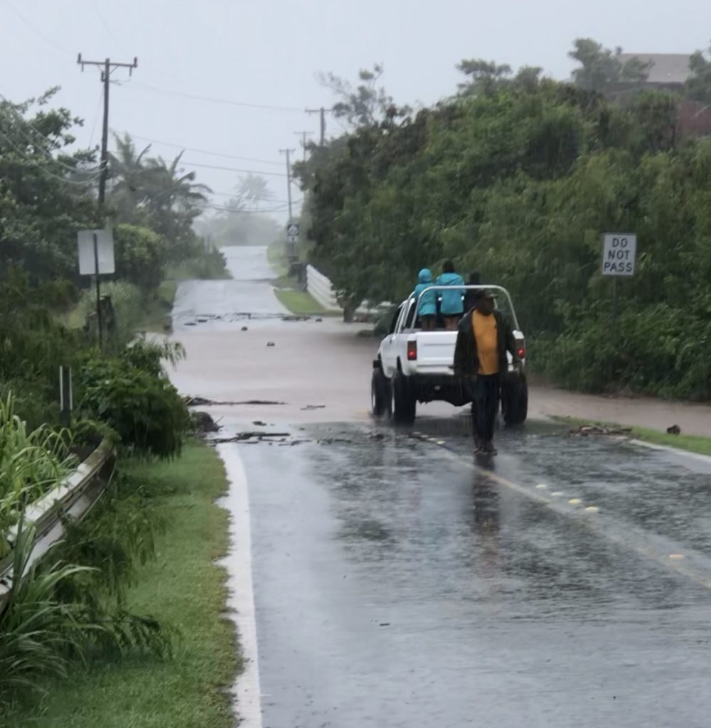
Debra Mapel, whose house is to the east of the stream, often assists Miguel with the heavy task of digging through the sand bar. If the plug isn’t cleared, she told Environment Hawai‘i, there’s the real danger that the stream will be effectively dammed. Water in the stream will rise and the debris it carries – rocks and vegetation from erosion along the channel upstream and branches shed by invasive Java plum trees, among other things – can wash up against the bridge just a few hundred feet away from the ocean. That bridge carries the only road, Kamehameha V Highway, that links Moloka‘i’s central town of Kaunakakai and its airport to Halawa Valley on the island’s eastern tip, around 9 miles away from the Waialua Stream bridge.
“If the bridge clogs, we’re doomed,” Mapel said.
‘We Had to Do Something’
On September 1, a tropical depression formed in the eastern Pacific Ocean, southwest of Mexico. A few days later, it became a tropical storm named Olivia. By September 7, it was a Category 4 hurricane headed straight to Hawai‘i.
The forecasts were alarming.
“When you have the governor and mayor on television, predicting doom and gloom, we had to do something,” Mapel said. “Nobody was coming to help us.”
Beginning on September 6, Miguel and Mapel began work on what Mapel describes as a catchment basin. “It was a joint project,” Mapel said. “I bought the fuel, he drove the equipment.” Miguel, a retired heavy equipment operator, drove a mini-excavator through property owned by Mapel and her partner, Jules Dudoit, onto two vacant lots immediately east of the stream. They then began creating an area intended to capture the stream’s burden of debris, branches, and rocks before it entered the oxbow bend just upstream of Miguel’s property.
On September 9, in anticipation of Hurricane Olivia hitting the isles, Governor David Ige signed an emergency proclamation declaring all four counties disaster areas. Two days later, Moloka‘i felt the storm’s impact, with Olivia dumping 10 inches of rain on Moloka‘i in 24 hours.
“Miguel’s yard filled with debris and we all flooded,” Mapel said. “The sand plug was blown out, but eventually high tides brought it back inside the stream.”
At some point in September, someone notified federal, state, and county agencies of the work Miguel and Mapel were undertaking.
On October 10, two inspectors from the Army Corps of Engineers visited the site. They estimated the basin – now called a diversion – to be about 450 feet long, 12 feet wide at the base, and 22 feet wide at the high water mark. From these dimensions, they figured the total area of excavation came to roughly a quarter of an acre and that some 1,679 cubic yards of material had been displaced from the vacant lots, which they determined were part of a wetland. It was their conclusion that this constituted a violation of the Clean Water Act.
Miguel says he was just following the stream’s original alignment.
“The reports make it sound like we dug the Panama Canal,” Mapel said.

Ownership Issues
Miguel does not own either of the two properties that were bisected by the channel he dug. He and Mapel had earlier received permission to clear invasive vegetation from one owner, who was not on the island when the storms hit.
In any event, obtaining permission from all the landowners would have been – and still is – problematic. One of the lots is owned by a family estate and an individual living on the mainland; taxes on that one-acre lot haven’t been paid in a decade. The other lot, about a third of an acre, has no fewer than 15 owners listed in county property tax records. Several of them are identified as deceased, others have no known address, and still others have mainland addresses in California and Florida. Taxes on this lot as well have been unpaid for more than a decade.
Yet in their report, the Corps of Engineers inspectors noted no such problem in obtaining owner permission to visit the site. “[T]he Corps received verbal permis- sion for access over the phone from Mr. Paul Cullen, land owner, on September 28,” their report states.
“Oh, God. Paul Cullen. Our worst nightmare.”
That was Mapel’s response when asked about Cullen’s involvement. “He lives in a blue tarp about a quarter-mile down the road,” she said. “He asked the county real property tax office to put his name on the tax record for one of the lots adjoining the stream, but he’s not an owner.”
The property tax record for the larger parcel does display Cullen’s name – but does not identify him as an owner. Mapel said that she had asked the tax office about this and was told that anyone can add their name to a property tax record as an “addressee.”
(Environment Hawai‘i made several calls to Maui County tax officials to explain how this could happen; none was returned by press time.)
Cullen also held himself out to be an owner when two Department of Health Clean Water Branch investigators, Bobbie Teixeira and Steven Chase, came to Moloka‘i on October 12. Accompanying them were Connor Adams of the Environmental Protection Agency and Anthony Fukuoka, a building inspector from Maui County.
In her write-up of the site visit, Teixeira noted that “Mr. Paul Cullen identified himself as a property owner.” She went on to note, however, that he was not listed as an owner in Maui County real property tax records.
Enforcement

At the time of the visit, Teixeira later wrote in the inspection report, “the diversion was open at both sides. Water from Waialua Stream was actively flowing through the diversion. Bare soil was observed within the diversion at the bottom and along the banks. Flow observed in the diversion was turbid brown. … The slopes along the diversion were exposed and unstabilized.”
Mapel disputes Teixeira’s claim that the area dug out by Miguel connected to the stream on both ends. “Two days earlier, when the Corps inspection occurred, photos showed the channel dry and returning to natural grade, not going completely across the makai lot,” she said. “But it had rained up the mountain the night before the DOH and EPA arrived, so brown water was flowing across the property.”
Miguel, Teixeira wrote, “stated that all work was done in preparation or response to impacts of several storms.” She then added, “During the 2018 hur- ricane season, multiple hurricanes and tropical storms were forecasted to impact the Hawaiian Islands. An Office of the Governor State of Hawai‘i Emergency Proclamation was issued for Hurricane Lane suspending Hawai‘i Water Pollution Laws …. However, a proclamation suspending [laws] for Hurricane Olivia was not declared.”
“Teixeira is wrong,” Mapel said. “The original proclamation was extended to a later date that included Hurricane Olivia.”
Miguel admitted that he had obtained no permits for the work from any agency. “However,” Teixeira said in her report, “he believed a 1986 Reconnaissance report written by the Soil Conservation Service provided coverage for the diversion work.”
On October 23, the Department of Health ordered Miguel to cease work. In a follow-up call from Teixeira in Decem- ber, Miguel acknowledged receiving the letter and said he had been advised by the county “to either obtain a grading permit or restore the ditch.” “Mr. Miguel stated that a grading permit was not obtained and no work at the ditch has been done,” Teixeira wrote in her report of the call.
On February 20, the Department of Health issued a Notice of Violation and Order to Miguel. Among other things, it required Miguel to submit a corrective action plan to the DOH within 60 days and, after receiving DOH approval, implement it within 30 days. In addition to receiving authorization from the private landowners and county, state, and federal agencies, “the corrective action plan must clearly detail how you will restore the diversion to pre-existing conditions as well as the Best Management Practices that will be implemented to prevent further discharges,” the order reads.
Also, Miguel was to pay an administrative penalty of $20,000 within 20 calendar days of the date the NOVO was served.
As allowed, Miguel requested a hearing, where Miguel could be assisted by counsel and present evidence and witnesses. Teixeira told Environment Hawai‘i, “Scheduling a hearing is pending, based on the outcome of ongoing negotiations.”
The Resolution
The EPA undertook its own investigation, sending a formal request for information to Miguel on April 4, 2019. (Explaining the dual enforcement actions, Teixeira said, “While the DOH and EPA often communicate and coordinate, both agencies are free to act independently of each other. In this case, both agencies took separate actions but seek similar outcomes.”)
Miguel responded to the EPA six weeks later, providing additional information and photographs. At that time, he said that he had begun earthmoving activity at the site on August 22 and did not cease work until after October 1.
In the consent order that the EPA eventually worked out with Miguel, the EPA notes that the wetlands “abut a perennial stream … which is a tributary to the Pacific Ocean, which are all ‘navigable waters’ and ‘waters of the United States’” under the federal Clean Water Act. Miguel’s work resulted in “earthen and biological materials, such as dirt, rocks, sand, and vegetative matter,” being placed in the water and wetlands. “By discharging dredged and fill material into waters of the U.S. without a … permit, [Miguel] has violated and continues to violate” Sections 301(a) and 404 of the Clean Water Act.
The consent order, signed by Miguel and effective on October 30, requires him to submit a draft restoration plan within 30 days of that date. Upon approval of the plan by the EPA, Miguel is to “obtain all the necessary and applicable federal (e.g., Corps authorization), state or local permits to conduct site wetland restoration activities described in the plan.” In addition, he is required to “obtain written consent from the current landowners to conduct such work on the site.” The restoration work is to be completed within 90 days of the approval.
Should Miguel not be able to obtain the landowners’ consent, or if he does not submit the required restoration plan, or if the EPA does not approve his plan, then he needs to prepare a mitigation plan. That plan, the consent order states, has to provide a “3:1 replacement to impact ratio” for the impacted wetlands – in other words, given that Miguel disturbed a quarter-acre of wetlands, he would need to provide mitigation for three-quarters of an acre of wetland loss. That could take the form of restoring wetlands elsewhere in the Waialua Stream watershed or require the purchase of mitigation credits “at a qualified mitigation bank.”
Miguel told Environment Hawai‘i that Alan Matsuda, an engineer on Maui, helped in preparing a restoration plan and that he did submit a plan by the deadline. At press time, Miguel and Mapel said EPA had not informed them that the plan had been approved.
In its press release announcing the consent order, the EPA’s Mike Stoker, administrator for the agency’s Pacific Southwest Region, stated: “Wetlands have a unique ecological importance on the island of Moloka‘i and must be protected. Healthy wetlands help filter stormwater, create sustainable habitats, and buffer communities from flooding.”
Mapel agrees, but adds, “In this case, the unhealthy and unmanaged wetlands have led to flooding, erosion, and ultimately reduced stream flow, which is not sufficient to blow out the sand plug.”
An Altered Channel
Mapel expressed frustration over the difficulties she and Miguel have experienced in their attempts to keep the stream flowing to the ocean by clearing a channel through the sand bar and dislodging debris that has been caught by the bridge.
“The flooding has been going on a long time,” she said. “For years, Chucky and I worked every agency. Everybody said it’s not their kuleana.”
More than a year after Miguel tried to divert the stream, “it’s filled up with rocks already,” Mapel said. She asked the DOH to revisit the site, but no one has yet come.
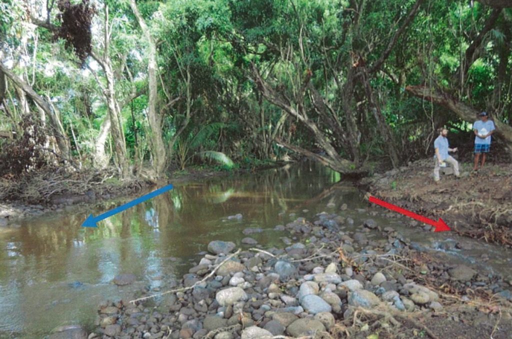
“The stream used to go straight at one time,” she said. “Now, every storm, it gets worse,” with the water taking huge chunks out of the land in the curve of the bow.
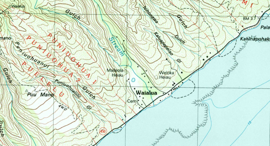
U.S. Geological Survey maps of eastern Moloka‘i bear out the claim of Mapel and Miguel that the natural channel of the stream has changed. The 1983 quad map of the area shows the stream entering the ocean practically perpendicular to the coast and the highway. There is no oxbow.

Today, the curve in the stream just mauka of the bridge is pronounced and the area where the channel goes under the bridge has shifted sharply to the north and east.
Mapel identified no shortage of contributing factors: the Java plum trees that have taken over areas that used to be carefully tended taro patches; the trails created by deer that then become highways for dislodged rocks and sediment; the high tides, higher king tides, and the rising sea level that wash sand into the stream mouth; and, not least, people who deliberately toss cut trees and other debris into the stream.
“The waterway isn’t maintained,” Mapel said.
A spokesperson for the state Department of Transportation was asked if the DOT had any responsibility to keep the stream clear as it passes under the bridge. She stated that the bridges and culverts on state roads are checked before approaching storms and also on twice-a- year inspections. If residents notice the sandbar clogging up flows at the stream mouth, they can ask the DOT to dredge it, she said.
In the meantime, the tides and storms continue to bring sand up the channel. In late December, it flooded again, Mapel said. “Chucky and Jules were over there with their shovels trying to open the sand plug on Christmas morning.”
More to Come?
The Hawai‘i Water Code requires permits be obtained for any work that alters a stream channel.
But as of press time, the Commission on Water Resource Management, which is responsible for investigating possible infractions and enforcing the Water Code, had not brought any enforcement action against Miguel.
A.J. McWhorter, a spokesperson for the Department of Land and Natural Resources, to which CWRM is administratively attached, said the agency “is planning to meet with the Department of Health’s Clean Water Branch in January to discuss and understand the situation, particularly with regards to the EPA’s actions, and to assess its own follow-up actions.”
The 2018 diversion is not the first time that Miguel has come to the attention of CWRM for his work in Waialua Stream. Teixeira’s inspection report includes this note: “On November 8, 2018, the Department of Land and Natural Resources provided the DOH-CWB with an investigation report that was conducted on March 4, 2010, in response to an alleged river diversion of Waialua Stream. The investigation report documented that Mr. Charles Miguel cleared land with a bulldozer with the intention of returning Waialua Stream to its original flow.”
When asked about this, Miguel told Environment Hawai‘i that he did “clean” the stream on the ocean side of the bridge a while back, but was never cited for that.
Mapel said that when she and Miguel were digging the ditch that is now the subject of so much agency attention, DLNR staff from its Division of Conservation and Resource Enforcement were actually on site. DOCARE officers informed Mapel and Miguel that they saw no problem with the work being done, since it was on dry land and did not involve any stream diversion.
— Patricia Tummons

Leave a Reply