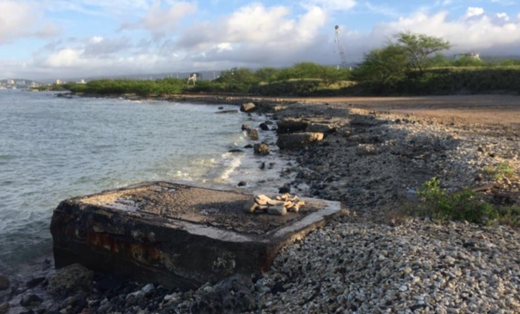
The Sand Island Wastewater Treatment Plant collects sewage from more than 400,000 residents and visitors in Honolulu and discharges 66 million gallons of effluent a day into the sea via along, wide underground outfall.
The 84-inch-wide outfall extends a mile offshore from a concrete-encased stop gate, which is a kind of valve that can control the effluent flow if necessary.
The problem: That gate, constructed in the 1970s more than 150 feet inland of the shoreline, is now at the water’s edge due to coastal erosion and sea level rise. And it’s already showing signs of wave damage.
So on August 23, despite its longstanding policy against shoreline hardening, the state Board of Land and Natural Resources approved a Conservation District Use Permit and a non-exclusive easement for a 550-foot-long rock revetment the city plans to build to protect the treatment plant’s outfall and stop gate from further damage.
Over the past several decades, the shoreline fronting the outfall and stop gate has shrunk, and erosion threatens to “expose and compromise the outfall pipeline,” according to a 2017 environmental assessment (EA) for the project. Between 2012 and 2017 alone, the shoreline eroded 20 feet, it stated.
A degraded revetment built in the mid-1970s offers minimal protection.
“Extreme wave and storm events can cause rapid erosion and damage to the shoreline. During such an event, the damage can occur over a short time span, possibly overnight. Climate change factors, including sea level rise, are likely to increase the near-shore wave exposure of the outfall,” the EA states.
Because the outfall is the only one serving the Honolulu area, “[f]ailure of or damage to the outfall could have catastrophic health, environmental, and economic consequences,” it states.
The new revetment is estimated to cost more than $12 million, but it could cost even more if the revetment doesn’t function as designed, which is what the Department of Land and Natural Resources’Office of Conservation and Coastal Lands(OCCL) suspects might happen.
In designing the revetment, the city’s consultant for the project used the U.S. Army Corps of Engineers’ sea level rise calculator to provide sea level rise projections through 2067. The final calculation was based on an estimate of a sea level rise of 1.5 feet over the 50-year intended design life of the structure, an August 23 OCCL report states.
“However, more recent sea level rise projections reveal that the project area is in a high-exposure area and that the entirety of the project area would very likely be inundated with just 0.5 feet of sea level rise,” the report continues.
The OCCL is referring to projections contained in the state’s Sea Level Rise Vulnerability and Adaptation Report, which was released after the EA for the revetment was completed. An online, interactive Sea Level Rise Viewer hosted by the University of Hawai‘i allows users to see how the report’s various projections affect coastal areas across the state.
In the case of the proposed Sand Island revetment, the breakwater section is intended to prevent flanking — when the land or sand at the ends of a coastal structure erodes — from the south. The OCCL suggests that the revetment should have been designed to protect flanking along its entirety. In its report, the OCCL points out that the Sea Level Rise Viewer places the area to the north end of the revetment also in the sea level rise exposure area.
“The applicant states that the northern end of the revetment would not be located at the shoreline and would be embedded into a higher elevation feature, but the Hawai‘i Sea Level Rise Viewer reveals that flanking around the northern tip of the wall is possible [and] that the entirety of the project area would very likely be inundated with just 1.1 feet of sea level rise, and even 0.5 feet of sea level rise in the area is projected to inundate almost all of the project area,” the report states.
Given that, the OCCL asked the city to report to it any flank erosion and to consult with the Department of Land and Natural Resources’ Division of State Parks on potential remediation if significant flank erosion occurs. The outfall crosses the state Sand Island Recreation Area before it enters the sea.
At the Land Board’s August 23 meeting, OCCL administrator Sam Lemmo explained that the project was exempt from the department’s prohibition on shoreline armoring because it is necessary to protect critical public infrastructure. “Having the outfall fail would be something on the order of a catastrophe for Honolulu,” he said. What’s more, there’s really no recreational beach to protect, since the whole area is filled land, he added.
“At the end of the day, we’re comfortable with approving, under the circumstances,” he said.
Normally, the DLNR’s Land Division would request separately that the Land Board approve an easement for the revetment. However, in an effort to streamline the approval process, that request came from the OCCL this time.
Lemmo also noted that his division, starting with this project, is now incorporating vulnerability maps from the Sea Level Rise Viewer in his office’s reports to the Land Board.
“You can see it will be impacted by sea level. It’s impacted as we speak,” Lemmo said of the Sand Island shoreline.

Leave a Reply